How dark is a dark sky? Measurements at seven sites
One camera, one lens, fixed settings and a Unihedron SQM-L across Crete, south-east Poland and central France, compared with the light-pollution atlas.
Light-pollution maps rate every location, often as a Bortle-style number. This dataset tests what differences at the dark end of that scale, such as 2.9 vs 3.9 on lightpollutionmap.info, mean for measured sky brightness at the zenith.
Measurements were taken at seven sites in three countries between August and November 2026 with identical equipment and settings.
This is a hobby project. I'm curious how these numbers compare with other hobbyists measuring with a Unihedron SQM in Europe.
Equipment and method
- Camera: Nikon Z5 with a Viltrox AF 16 mm f/1.8 Z, at f/1.8, 30 s, ISO 800 for every frame. A few early frames at f/2.2 are scaled to f/1.8.
- Meter: Unihedron SQM-L, whose lens narrows its field of view to about 20° (FWHM), reading in mag/arcsec². Higher values mean a darker sky.
- Position and time: logged on a phone with GPS for each reading and at the start of each camera sequence, as the Z5 has no GPS.
Each frame is plate-solved against a star catalogue, which gives its exact pointing, galactic latitude, and sun and moon altitude. The sky background is measured in a 15° cone around the frame centre, corrected for vignetting, and converted to mag/arcsec².
Only frames meeting all of these conditions are compared between sites:
- altitude at least 60°;
- at least 14° from the galactic plane;
- sun below −18° and moon below the horizon.
Camera values use one fixed calibration for this camera, lens and settings. They are consistent with each other but are not on the same scale as the meter.
Why the camera and meter numbers differ
At the same stop, the camera reads 0.5–0.7 mag darker than the Unihedron SQM-L. The two are deliberately not calibrated onto one scale:
- They measure different things. The camera value uses only the green channel in a patch about 30° across, and its scale comes from catalogue star magnitudes, close to the standard V band. The SQM-L responds to a broad band that includes red light, in a patch about 20° across.
- The gap is not constant. It was 0.62–0.71 mag in France and about 0.5–0.6 mag in Roztocze, larger where the sky was redder. A single correction would leave errors of up to about 0.15 mag, as large as the differences between sites.
- Red airglow may explain it. Oxygen airglow at 630 nm is visible to the SQM-L but barely to the green channel. This is untested.
Compare camera values with camera values, and meter values with meter values.
Results
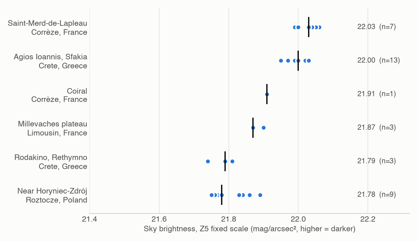
| Site | Camera | Meter | Atlas zone |
|---|---|---|---|
| Saint-Merd-de-Lapleau (Corrèze, France) | 22.03 | 21.33–21.40 | 1b |
| Agios Ioannis, Sfakia (Crete, Greece) | 22.00 | n/a | 2b |
| Coiral (Corrèze, France) | 21.91 | 21.25–21.36 | 1b |
| Millevaches plateau (Limousin, France) | 21.87 | 21.16–21.27 | 1b |
| Rodakino, Rethymno (Crete, Greece) | 21.79 | n/a | 3a |
| Near Horyniec-Zdrój (Roztocze, Poland) | 21.78 | 21.26–21.29 | 2b |
Meter values are per-stop medians. The Crete sites were measured only with an earlier, non-comparable meter.
The Millevaches plateau is the Millevaches en Limousin International Dark Sky Reserve (Réserve internationale de ciel étoilé), designated by DarkSky International in November 2021. Its meter range comes from nine stops spread across the plateau, all on one night between 20:36 and 22:45. Camera frames were taken at two of them. Those readings started earlier in the evening than at the Corrèze sites, which may account for part of the difference.
Findings
The atlas agrees at the dark end. The darkest Corrèze sites show 2.9 on lightpollutionmap.info and the Roztocze site 3.9. At this end of the scale a step of 0.1 is about 0.015 mag, so the difference predicts about 0.15 mag. The measured difference was 0.05–0.25 mag, depending on instrument and night.
The best Crete site matched the darkest French sites. Agios Ioannis, on the plateau above Chora Sfakion at about 760 m, measured 22.00, against 22.03 for Saint-Merd-de-Lapleau, although the atlas places it two zones brighter.
Proximity to a main road had no measurable effect. Three stops near a main road west of Saint-Merd-de-Lapleau (Corrèze, France) read 21.30–21.34 on the meter. Coiral and lanes near Saint-Merd read 21.25–21.40 later the same evening.
Focus matters. Six out-of-focus frames read about 0.1 mag brighter than sharp frames of the same sky, because smeared starlight is counted as background. This is comparable to some differences between sites, so those frames were excluded.
Sky colour differed between regions. The red/green ratio of the sky background was 0.62–0.67 in France and 0.53–0.57 in Poland. Across all sessions it follows solar activity (F10.7), which drives red oxygen airglow. Site, season and solar activity changed together in this dataset, so the cause is not established.
Horizon glow
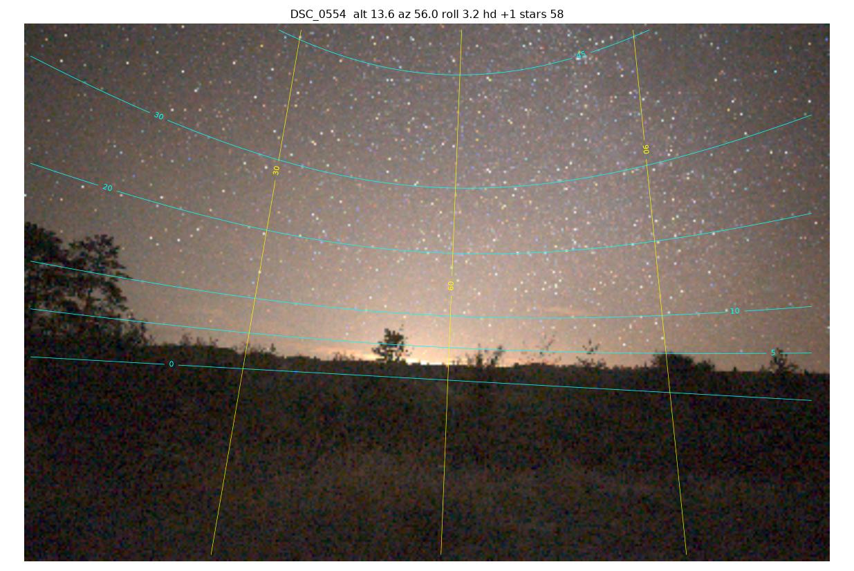
Artificial light is identifiable near the horizon because it stays at a fixed bearing while the sky rotates. This glow fades by about 15° altitude. A second glow to the west matches the bearing of Tulle, 26 km away, and was lighting low cloud. At equal altitudes, the east-north-east glow was 0.25–0.35 mag fainter than the brightest horizon glow at the Roztocze site.
At the zenith, a single measurement cannot be split into artificial light, airglow and starlight.
Limitations
- Few nights and few qualifying frames per site, in one case a single frame.
- Sites were measured at different times of night, in different seasons and at different levels of solar activity.
- Some meter stops include readings deliberately aimed away from the zenith, which are not marked.
- The camera calibration derives from a single reference frame, so it is a relative scale for this camera only.
Open questions
The raw frames, all meter readings and the scripts are on GitHub. Contributions are welcome on:
- Atlas accuracy at the dark end elsewhere. More sites measured with both a meter and a fixed camera would test it.
- Separating artificial light from airglow at the zenith. Candidate approaches are lamp switch-off timing, many nights at one site, and low-cost spectroscopy.
- Sky colour and solar activity. This needs one site measured over many months.
The scripts run on any camera locked to fixed settings, after deriving its own calibration constant as described in the repository. Discussion is open on GitHub.
If you measure with a Unihedron SQM anywhere in Europe, I'd be glad to hear from you and compare readings, even without a camera.
The photos and meter readings were taken by hand in the field. The scripts, much of the analysis, and the draft of this text were produced with Claude Code, an AI coding assistant. Errors were found and corrected during the work, and some may remain. The raw data is public so it can be checked.